 Ecuador
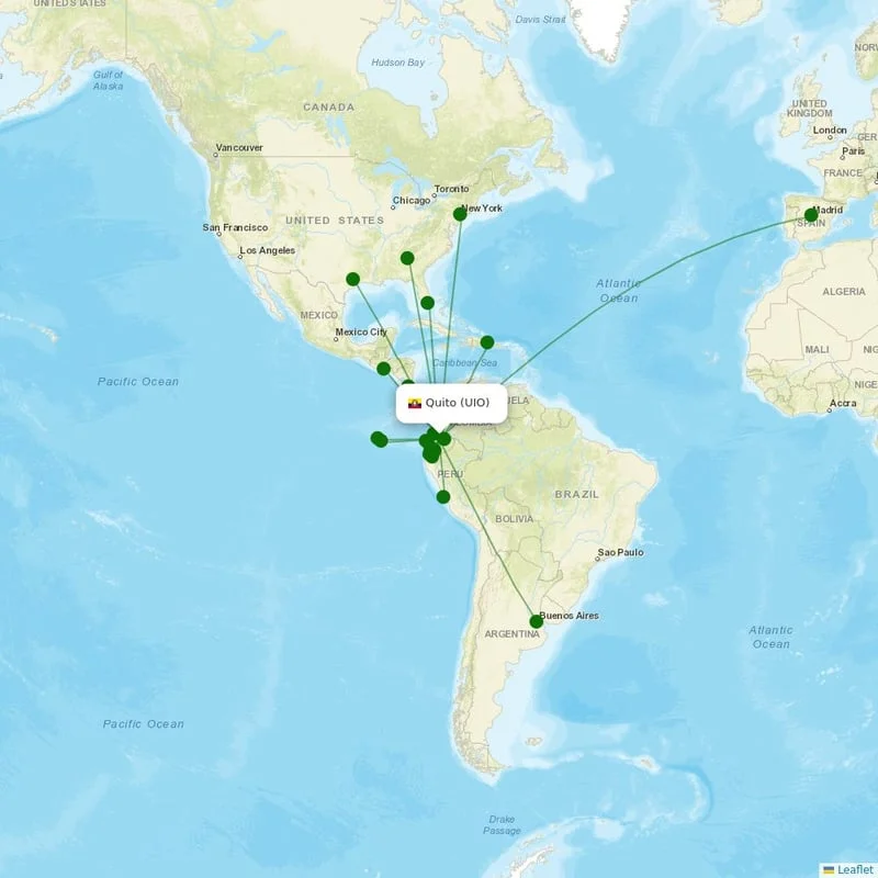
Quito, Ecuador
Location
UTC
Timezone
-0.1254 S, -78.3543 W
Coordinates
7,841 ft (2,390 m)
Elevation
Loading flights...
What is Mariscal Sucre International Airport?
Mariscal Sucre International Airport (UIO/SEQM) is Large Airport serving Quito in Ecuador. Located at coordinates 0.1254 S, 78.3543 W, the airport sits at an elevation of 7,841 feet (2,390 meters) above sea level. Operating in the UTC timezone, the airport offers scheduled commercial flights to various destinations.
Current Weather

Local Time
Wednesday, June 3, 2026
Timezone Information
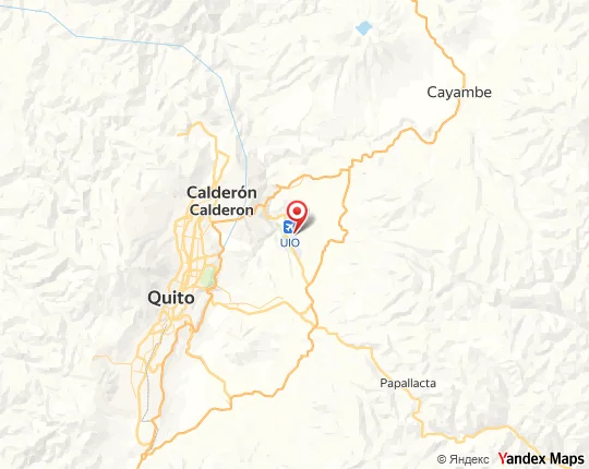
Where is Mariscal Sucre International Airport on Map?
View the exact location of Mariscal Sucre International Airport on the interactive map below.
Geographic Information
Ecuador (EC) Location Map
Runways at Mariscal Sucre International Airport
Mariscal Sucre International Airport has 2 runway(s). Below you can find detailed information about each runway including dimensions and surface type.
Terminals at Mariscal Sucre International Airport
Mariscal Sucre International Airport has 1 terminal(s). Below you can find the list of terminals and buildings at this airport.
Radio Frequencies at Mariscal Sucre International Airport
Communication frequencies for pilots and aviation personnel at Mariscal Sucre International Airport. These frequencies are used for air traffic control, ground operations, and airport information services.
| Type | Frequency | Description |
|---|---|---|
| APPR | 119.700 MHz | Quito Approach |
| APPR2 | 121.200 MHz | Quito Approach |
| ATIS | 119.800 MHz | ATIS |
| GRD | 121.900 MHz | Quito Ground |
| TWR | 118.100 MHz | Quito Tower |

About Mariscal Sucre International Airport
Mariscal Sucre International Airport is an international airport serving Quito, Ecuador. It is the busiest airport in Ecuador. It is located in the Tababela parish, about 18 kilometres (11 mi) east of Quito, and because of its location it is also colloquially known as Tababela Airport. The airport currently serves as the main hub for Avianca Ecuador and the largest hub for LATAM Ecuador. It also served as the main hub for TAME, Ecuador's flag-carrier, before the airline was liquidated by the Ecuadorian government in 2020. The airport opened in February 2013 and replaced the 53-year old airport of the same name. The airport is named after independence leader Antonio José de Sucre. It was the first 5-star airport in the Western Hemisphere as rated by Skytrax.
Read more on WikipediaAirport Analysis for Mariscal Sucre International Airport
Nearby Airports to Mariscal Sucre International Airport
Explore other airports located within a 300km radius of Mariscal Sucre International Airport. This can help you find alternative travel options or nearby facilities.
Distance to Major Cities
Flight distances and estimated travel times from Mariscal Sucre International Airport to major world cities.
Nearby Cities to Mariscal Sucre International Airport
Explore cities in Ecuador that are easily accessible from Mariscal Sucre International Airport. Discover nearby destinations with estimated driving distances and times.
Closest States to Mariscal Sucre International Airport
Explore nearby states in Ecuador accessible from Mariscal Sucre International Airport. Plan your regional travel with distance information.
Discover other major airports in Ecuador. Compare distances and explore alternative departure points for your travel plans.
Explore connections to major international airports around the world from Mariscal Sucre International Airport. Find global destinations and plan your international travel.
Reviews & Ratings
Share your experience at Mariscal Sucre International Airport
No reviews yet. Be the first to review this airport!