 United States
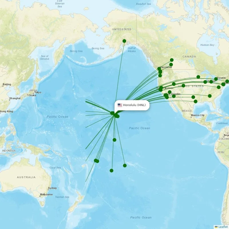
Honolulu, Oahu, United States
Location
UTC
Timezone
21.3184 N, -157.9257 W
Coordinates
13 ft (4 m)
Elevation
Loading flights...
What is Daniel K. Inouye International Airport?
Daniel K. Inouye International Airport (HNL/PHNL) is Large Airport serving Honolulu, Oahu in United States. Located at coordinates 21.3184 N, 157.9257 W, the airport sits at an elevation of 13 feet (4 meters) above sea level. Operating in the UTC timezone, the airport offers scheduled commercial flights to various destinations.
Current Weather

Local Time
Wednesday, June 3, 2026
Timezone Information
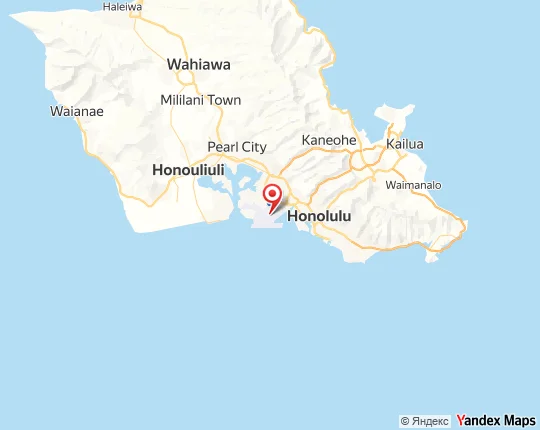
Where is Daniel K. Inouye International Airport on Map?
View the exact location of Daniel K. Inouye International Airport on the interactive map below.
Geographic Information
United States (US) Location Map
Runways at Daniel K. Inouye International Airport
Daniel K. Inouye International Airport has 12 runway(s). Below you can find detailed information about each runway including dimensions and surface type.
Terminals at Daniel K. Inouye International Airport
Daniel K. Inouye International Airport has 2 terminal(s). Below you can find the list of terminals and buildings at this airport.
Radio Frequencies at Daniel K. Inouye International Airport
Communication frequencies for pilots and aviation personnel at Daniel K. Inouye International Airport. These frequencies are used for air traffic control, ground operations, and airport information services.
| Type | Frequency | Description |
|---|---|---|
| APPR | 118.300 MHz | - |
| ATIS | 127.900 MHz | - |
| CLRN | 121.400 MHz | - |
| DEPT | 118.300 MHz | - |
| GND | 121.900 MHz | - |
| TWR | 118.100 MHz | - |
About Daniel K. Inouye International Airport
Daniel K. Inouye International Airport, also known as Honolulu International Airport, is the primary airport serving the U.S. state of Hawaii. The airport is named after Honolulu native and Medal of Honor recipient Daniel Inouye (1924–2012), who represented Hawaii in the United States Senate from 1963 until his death in 2012. The airport is in the Honolulu census-designated place three miles northwest of Honolulu's central business district. The airport covers 4,220 acres, more than 1% of the entire Oahu Island.
Read more on WikipediaAirport Analysis for Daniel K. Inouye International Airport
Distance to Major Cities
Flight distances and estimated travel times from Daniel K. Inouye International Airport to major world cities.
Nearby Cities to Daniel K. Inouye International Airport
Explore cities in United States that are easily accessible from Daniel K. Inouye International Airport. Discover nearby destinations with estimated driving distances and times.
Closest States to Daniel K. Inouye International Airport
Explore nearby states in United States accessible from Daniel K. Inouye International Airport. Plan your regional travel with distance information.
Reviews & Ratings
Share your experience at Daniel K. Inouye International Airport
No reviews yet. Be the first to review this airport!